Penrith City Local History - Places - Suburb profiles - Wallacia
Wallacia
Wallacia is located at the most southerly region of the City of Penrith. Wallacia is a small village surrounded by rural countryside. The Nepean River takes a severe turn westward at Wallacia, gradually turning northerly again at Mulgoa. At Wallacia, the river rises to a height of 300m above sea level. Wallacia was a renowned holiday resort area from the late 1800s to the 1940s. It is also well known for its quiet village lifestyle. The Wallacia Hotel and Wallacia Golf Course reflect the recreational qualities of the area.
Wallacia on Google Maps.
When the Post Office became official in November 1905, the G.P.O. named the area Boondah as the name Wallace was already in use elsewhere in NSW. Local people objected however, as they wished to retain the link with Wallace. To overcome the problem, they suggested that the area be called Wallacia. This name was officially approved on 1 June, 1906.
The region was chiefly one of dairying and grazing during the nineteenth century, but in the early twentieth century – because of its rural atmosphere and proximity to Sydney – tourism developed as people opened their homes as guest houses. After the Second World War however, the increase in car ownership and the availability of air travel saw a decline in the local tourist trade. Today Wallacia’s tourism is centred on the day-tripper trade with the Wallacia Hotel and the Wallacia Golf Course the chief attractions. Growth in the area in the past few years has mainly occurred with the development of hobby farms by people seeking a retreat from city life.
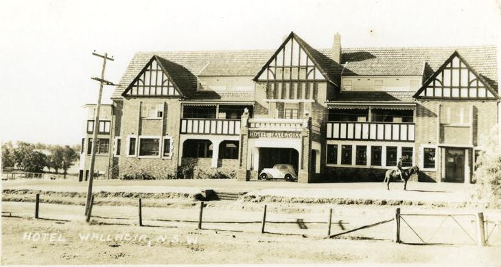
Wallacia Hotel
The Wallacia Hotel was officially opened on December 3rd 1937. During the Second World War the hotel was used as the Army headquarters for radiophysics. The hotel, which was built in the mock tudor style, is heritage listed under Penrith City Council’s Local Environmental Plan.
| 1801 | October | George Caley with 2 convicts explored the Nepean River between Cobbitty and Wallacia |
| 1802 | September | Lt Francis Barrallier explored the Nepean River at Wallacia |
| 1804 | September | Surveyor George Evans discovered the Warragamba River |
| 1810 | November | Governor Macquarie and his party explored the area Evans discovered |
| 1813 | 30 November | John Blaxland granted 6170 acres, which he named “Luddenham” |
| 1816 | 8 October | Dennis McDonald granted 30 acres |
| 1831 | Blaxland granted a further 777 acres between the Nepean River and the Warragamba River, which included Grove Farm | |
| 1851 | Sir Charles Nicholson (benefactor to the (University of Sydney) purchased Blaxland’s land | |
| 1883 | Nicholson’s land gradually sold and sub-divided | |
| 1885 | November | Official Post Office opened with the area named Boondah |
| 1896 | 11 December | Unsuccessful application for a provisional school |
| 1897 | 19 April | New half-time school building completed |
| 1906 | 1 June | Riverview, Wallace and Boondah renamed Wallacia |
| 1910 | December | Land purchased by the Crown for a School |
| 1912 | Wallacia Weir built | |
| 1920s | Guesthouses boomed in the Wallacia area | |
| 1923 | Thistledome Guesthouse built on Greendale Road | |
| 1923 | Roselea Guesthouse on Greendale Road built by the Downes family | |
| 1927 | December | Land gazetted as a public school |
| 1937 | December | Wallacia Hotel opened |
| 1958 | 3 October | Corner Water Street and Mulgoa Road dedicated for a War Memoria |
| 1984 | Local Environmental Study of Mulgoa and Wallacia (Penrith City Council) | |
| 1999 | June | Release of the Mulgoa & Wallacia Study and Strategy by Penrith City Council |
| 2019 | July | Plans to turn Wallacia Golf and Country Club into an 80,000 plot cemetery are knocked back |